|
|
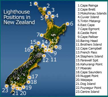
New Zealand Lighthouses |
|
|
New Zealand Lighthouses |
The above lights are owned by MSA. Others are
owned by Harbour Authorities.
Alphabetical Listing and Some
Photos of New Zealand Lighthouses showing Position, Reference Number etc.
The list is limited to structures of some substantial size and importance.
Navigation lights on poles, for example, are not included.
Any photos would be appreciated as jpg's. Please send a message to me here and I will contact you direct.
|
Name |
Lat S / Long E |
K number |
NZART |
Owner |
Comments |
|
|
46 53.7 / 168 09.8 |
4388 |
- |
msa |
White wooden tower, 20masl, 5m high, W7R4 miles |
||
|
43 53.5 / 172 58.7 |
4314 |
1/30 |
- |
- |
||
|
41 24.6 / 174 52.2 |
4004 |
1/10 |
msa |
1935- |
||
|
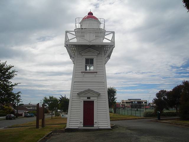
Bean Rock |
36 50.1 / 174 49.9 |
3748 |
1/10 |
Auk Ccl |
White metal lattice tower, 15m asl, 4m high, W14R11 miles. |
|
|
Bream Head |
35 50.8 / 174 34.9 |
3713 |
- |
- |
White metal tower, 172m asl, 4m high, 10 miles. |
|
|
41 06.2 / 174 26.5 |
4246 |
2/30 |
msa |
1877- |
||
|
46 36.4 / 168 31.1 |
4387 |
- |
msa |
Grey metal lattice tower, 17masl, 12m high, 9 miles range. |
||
|
35 10.5 / 174 19.9 |
3709 |
1/30 |
msa |
- |
||
|
41 43.8 / 174 16.5 |
4274 |
1/30 |
msa |
- |
||
|
39 16.6 / 173 45.2 |
4088 |
1/30 |
msa |
White metal tower, 33 masl, 20m high, 19 miles range. |
||
|
40 30.4 / 172 42.8 |
4180 |
- |
msa |
White metal tower, 166masl, 4m high, 10 miles range |
||
|
41 45.1 / 171 28.0 |
4486 |
1/30 |
msa |
White conc. tower, 70masl, 9m high, 9 miles. |
||
|
Cape Jackson |
40 59.7 / 174 18.8 |
4244 |
- |
msa |
White metal tower, 87masl, 4m high, 9 miles range. |
|
|
Cape Jackson, Rock. |
41 06.2 / 174 19.1 |
4244.5 |
- |
msa |
White round tower, 15masl, 15m high, 3 miles range. |
|
|
Cape Karikari |
34 47.0 / 173 23.8 |
3694 |
- |
- |
White tower, 59masl, 3m high, 10 miles range. |
|
|
39 38.8 / 177 05.5 |
3992 |
- |
- |
- |
||
|
34 28.8 / 172 38.7 |
3686 |
- |
- |
- |
||
|
41 36.8 / 175 17.4 |
4000 |
2/30 |
msa |
- |
||
|
45 59.9 / 166 26.9 |
4444 |
- |
msa |
White tower, 60masl, 4m high, 9 miles. |
||
|
34 25.7 / 172 40.6 |
3688 |
2/30 |
msa |
- |
||
|
36 16.8 / 174 49.3 |
3736.6 |
- |
- |
- |
||
|
37 32.4 / 177 59.2 |
3929 |
- |
- |
White GRP tower, 57m asl, 3m high, 9 miles. |
||
|
45 53.0 / 170 43.7 |
4376 |
1/10 |
msa |
- |
||
|
Castlecliff |
39 55.7 / 174 58.2 |
4070 |
- |
- |
White lattice tower, 37masl, 8m high, 18 miles |
|
|
40 54.1 / 176 13.9 |
3994 |
2/30 |
msa |
- |
||
|
34 58.6 / 173 57.9 |
3699 |
- |
- |
White metal tower, 111masl, 4m high, 7 miles. |
||
|
46 27.7 / 167 50.7 |
4438 |
1/30 |
msa |
- |
||
|
35 53.3 / 174 46.8 |
3714 |
- |
- |
White metal tower, 145m asl, 3m high, 9 miles. |
||
|
36 26.5 / 175 47.2 |
3886 |
3/30 |
msa |
- |
||
|
46 39.2 / 168 24.6 |
4394 |
1/30 |
msa |
- |
||
|
45 43.7 / 166 27.5 |
4446 |
- |
msa |
Metal lattice tower, 166masl, 9m high, 9 miles. |
||
|
37 41.5 / 178 32.9 |
3932 |
2/30 |
msa |
- |
||
|
Farewell Spit Bush-end Point |
40 32.9 / 173 00.6 |
4182 |
2/30 |
msa |
- |
|
|
36 26.8 / 174 55.5 |
3738 |
- |
- |
- |
||
|
Fraser Rock |
35 14.6 / 174 07.0 |
3700 |
- |
- |
Red conc. tower, 13masl, 3m high, W9R8 miles |
|
|
40 55.5 / 173 50.1 |
4238 |
- |
msa |
- |
||
|
38 31.5 / 178 17.4 |
3950 |
- |
- |
White metal tower, 210m asl, 4m high, 19 miles range |
||
|
Gisborne Harbour front |
38 40.5 / 177 59.3 |
3958 |
- |
- |
Metal lattice tower, 12m asl, 10m high, 7 miles. |
|
|
Gisborne Harbour rear |
38 40.3 / 177 59.1 |
3958.1 |
- |
- |
Metal lattice tower, 21m asl, 21m high, 7 miles. |
|
|
Goat Point, Mana |
41 05.4 / 174 52.0 |
4066.3 |
- |
- |
Nearest structure to Mana (NZL 032) |
|
|
Godley Head |
43 35.3 / 172 48.5 |
4286 |
1/10 |
- |
Tower brown cupola White base, 97masl, 6m high, 17 miles range. |
|
|
Governors Bay, Lyttleton Harb. |
43 37.3 / 172 38.9 |
4289 |
- |
- |
Grey concrete shed red roof, 65masl, 3m high, 19 miles range. |
|
|
43 35.4 / 169 33.3 |
4468 |
- |
msa |
White GRP tower, 77masl, 9 miles range. |
||
|
Heyward Point |
45 45.5 / 170 41.5 |
4362 |
- |
- |
White tower, 25masl, 4m high, W9R7 miles range. |
|
|
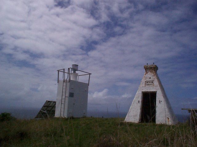
42°42' / 171°0'E |
**** |
- |
- |
Restored by Historical Society. see here. |
||
| Jack's Point Sth of Timaru | - | - | - | - | - | |
|
43 57.7 / 168 37.3 |
4466 |
- |
msa |
White metal tower, 155masl, 4m high, 9 miles. |
||
|
40 46.7 / 172 13.2 |
4506 |
3/30 |
msa |
- |
||
|
36 21.5 / 174 11.0 |
4130 |
- |
- |
- |
||
|
Karori Rock |
- |
- |
- |
- |
Disused structure, see Tongue Point (K 4062.1) |
|
|
36 23.5 / 174 50.4 |
3738.2 |
- |
- |
White metal tower, 34m asl, 4m high, W8R6 miles |
||
|
Limestone Island Front |
35 46.7 / 174 21.2 |
3724.2 |
- |
- |
Framework tower, 12m asl, 12m high, 5 miles. |
|
|
Limestone Island Rear |
35 47.1 / 174 21.3 |
3724.21 |
- |
- |
Framework tower, 20m asl, 4m high, 4 miles. |
|
|
46 15.3 / 167 06.4 |
4440 |
- |
msa |
Aluminium tower, 23masl, 4m high, 9 miles range. |
||
|
Mana Island |
- |
- |
- |
- |
Structure moved to Cape Egmont (K 4088) |
|
|
Manakau South Head |
37 03.2 / 174 32.7 |
4108 |
- |
- |
White wooden structure, 234masl, 12 miles range. |
|
|
Marseden Point |
35 50.3 / 174 30.0 |
3716 |
- |
- |
Metal lattice tower, 22m asl, W10R7G7 miles range |
|
|
Mikotahi (Port Taranaki) |
39 03.4 / 174 01.7 |
4090 |
- |
- |
Grey metal tower white top, 30masl, 10 miles range |
|
|
45 23.7 / 170 52.0 |
4360 |
1/30 |
msa |
- |
||
|
35 54.5 / 175 06.9 |
3734 |
5/30 |
msa |
- |
||
|
Motuara Island S end. |
41 06.0 / 174 16.5 |
4248 |
- |
- |
White metal lattice tower, 28masl, 5m high, 8 miles range. |
|
|
34 24.9 / 173 03.0 |
3690 |
- |
- |
- |
||
|
46 27.0 / 169 49.0 |
4380 |
2/30 |
msa |
White stone tower, 76masl, 9m high, 19 miles range. |
||
|
Oaonui, Wanganui River. |
39 25.6 / 173 49.2 |
4085 |
- |
- |
Black metal structure white stripes, 37masl,11m high, W12R10 miles |
|
|
41 14.6 / 174 38.7 |
4066.2 |
- |
- |
Nearest structure to Quartz Hill (NZL 044) |
||
|
36 43.7 / 175 52.6 |
3892 |
- |
- |
White metal tower, 105m asl, 4m high, 9 miles range. |
||
|
40 58.6 / 173 45.7 |
4234 |
- |
msa |
White metal tower, 34masl, 3m high, W8R5 miles range. |
||
|
Parengarenga Harbour |
34 31.3 / 172 58.1 |
3690.4 |
- |
- |
Orange square tower. 47m asl, 5m high, 6 miles |
|
|
41 21.7 / 174 50.9 |
4006 |
1/10 |
- |
- |
||
|
Perpindicular Point |
34 49.5 / 173 10.0 |
3690.7 |
- |
- |
Square beacon, 97m asl, 6 miles. |
|
|
Piha, Manukau Harbour |
36 58.2 / 174 28.1 |
4122 |
- |
msa |
White concrete tower, 266masl, 5m high, 20 miles range. |
|
|
Point Gibson. |
42 53.0 / 173 19.0 |
4279 |
- |
msa |
Red metal tower white bands, 76masl, 3m high, 10 miles range. |
|
|
Point Halswell |
41 17.1 / 174 49.6 |
4018 |
- |
- |
Black & white check tower, 8masl, 6m high, 15 miles range. |
|
|
42 25.6 / 173 42.9 |
4275 |
- |
msa |
Yellow metal tower, 41masl, 4m high, 9 miles range. |
||
|
35 26.9 / 174 44.2 |
3711 |
- |
- |
White metal tower, 158masl, 4m high, 17 miles. |
||
|
41 16.1 / 173 15.7 |
4227 |
1/10 |
Nelson C |
- |
||
|
Port Nelson, Landfall |
41 15.4 / 173 16.8 |
4224 |
- |
- |
Metal lattice tower, 22masl, 18m high, 22 miles range. |
|
|
Port Nelson, Schnapper |
41 12.2 / 173 19.4 |
4222 |
- |
- |
Concrete column, 13masl, 11m high, W15R8 miles range. |
|
|
39 18.3 / 177 52.0 |
3970 |
2/30 |
- |
- |
||
|
36 21.8 / 174 10.9 |
4130 |
- |
- |
White tower, 6masl, 4m high, 6 miles range. |
||
|
Purau Bay, Lyttleton Harbour. |
43 37.5 / 172 44.6 |
4288 |
- |
- |
Grey concrete shed, red roof, 54masl, 3m high, 15 miles range. |
|
|
46 09.5 / 166 36.6 |
4442 |
5/30 |
msa |
- |
||
|
Rangitoto |
36 47.0 / 174 49.3 |
3744 |
- |
- |
- |
|
|
44 34.4 / 167 46.9 |
4464 |
- |
- |
- |
||
|
45 13.5 / 166 52.4 |
4452 |
- |
msa |
Metal pedestal, 52masl, 2m high, 9 miles range. |
||
|
40 47.0 / 172 59.9 |
4204 |
- |
- |
- |
||
|
37 03.0 / 175 57.3 |
3896 |
- |
- |
- |
||
|
46 40.5 / 169 00.1 |
4382 |
- |
msa |
White round metal tower, 33masl, 3m high, 8 miles range. |
||
|
41 15.7 / 174 51.8 |
4014 |
1/10 |
- |
- |
||
|
South Head, Kaipara Harbour. |
36 25.7 / 174 14.1 |
4132 |
- |
- |
White round tower, 41masl, 4m high, 8 miles range |
|
|
44 34.5 / 167 46.8 |
4464 |
- |
msa |
White tower, 27masl, 6m high, 9 miles. |
||
|
43 44.7 / 173 07.7 |
4310 |
- |
msa |
White metal tower, 156masl, 4m high, 19 miles range. |
||
|
40 40.1 / 174 00.0 |
4236 |
5/30 |
msa |
- |
||
|
Stevens Point leading lights F |
35 48.6 / 174 27.0 |
3719 |
- |
- |
Metal lattice tower, 13m asl. 13m high, 9 miles. |
|
|
Stevens Point leading lights R |
35 45.8 / 174 22.1 |
3719.1 |
- |
- |
Metal lattice tower, 25m asl, 6m high, 9 miles. |
|
|
Taharoa, Ironsand Terminal |
38 09.4 / 174 42.3 |
4096 |
- |
- |
White metal lattice tower, 36masl, 16m high, 12 miles range. |
|
|
45 46.5 / 170 43.7 |
4364 |
1/10 |
- |
- |
||
|
35 11.2 / 173 03.5 |
4153 |
- |
- |
- |
||
|
46 36.8 / 169 26.3 |
4381 |
- |
msa |
White tower, 32masl, 4m high, 8 miles range. |
||
|
The Mount, Tauranga Harbour. |
37 37.6 / 176 10.4 |
3899 |
- |
- |
White square concrete structure, 80masl. 1m high, 24 miles |
|
|
43 23.0 / 171 18.1 |
4322 |
- |
- |
- |
||
|
36 36.4 / 174 53.8 |
3740 |
1/10 |
msa |
- |
||
|
41 20.5 / 174 39.6 |
4062.1 |
- |
- |
Adjacent to Karori Rock (NZL 031) |
||
|
35 36.8 / 174 32.7 |
3712 |
- |
- |
White metal tower, 92m asl, 4m high, 19 miles. |
||
|
46 39.8 / 168 50.7 |
4384 |
2/30 |
msa |
- |
||
|
Wellington Harbour front |
41 19.2 / 174 51.3 |
4010 |
- |
- |
White tower on black metal base, 7masl, 4m high, 21 miles |
|
|
Wellington Harbour rear. |
41 17.8 / 174 51.9 |
4010.1 |
- |
- |
Steel cylinder with orange & yellow stripes, 17masl, W22R8G11 |
|
|
West Head, Tory Channel. |
41 12.8 / 174 18.9 |
4262 |
- |
- |
White tower, 46masl, 4m high, 8 miles range. |
|
|
Westport and Buller River |
41 43.8 / 171 35.2 |
4490 |
- |
- |
White square conc. tower, 20masl, 8 miles range |
|
|
Whirinaki Point |
39 21.8 / 176 54.1 |
3980 |
- |
|
- |
Metal tower red & white bands, 59masl, 16m high, W17R14G14 miles |
Notes: NZART Award: Guiding Light Award; requires contacts with stations within 30km of the more remote lighthouses and 10km of the lighthouse near cities. Depending on the degree of difficulty, each light has been allocated 1 to 5 points. A total of 20 points is required for the basic "Mariners" Award and 50 points for the "Master Mariners" Award. Column 4 shows points/kilometers. Full log sheets available from Awards manager. Eligible contacts for this award must be dated November1 1998 or later. Cost of both awards $5.00NZ, overseas $5US or 5 irc's. Applications to NZART Awards Manager.
"K" Numbers are the British Admiralty List of
Lights and Fog Signals Vol K Reference numbers.
"masl" means meters above sea level of light source, "m
high" means height of structure in meters, "range" is the
distance in sea miles that the light may be seen at sea.
More photographs: http://home.wanadoo.nl/oostrumtenklooster/lighthouses.html
A particular thank-you to Heidi Hansen of the New Zealand Maritime Safety Authority for some of the photos used and also to Gary Montagu who povided quite a few other photos. None of the photos on these pages were taken by me but I have obtained permission to use them from the owners thereof. This permission does not extend to their use on other web sites and to do so is a breach of copyright and net etiquette.
This list was originally compiled by Gavin ZL2ACT for amateur radio events.
Last Updated on 29 June, 2009